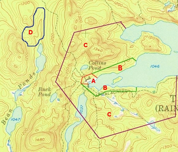
The following image depicts a typical layering of land use and conservation needs surrounding a traditional sporting camp. The Maine Sporting Camp heritage Foundation compiles an inventory of this pattern for each sporting camp, and then prioritizes a strategy to conserve each layer.
Camp Lot (A – Red Zone) – Land directly under and around sporting camp. 20 to 100 acres typical. Private property with no open public access. Assures sporting camp’s future right to remain in place. Property would be purchased by foundation and leased to camp owner with appropriate terms and conditions. Ownership or a long term lease is critical to encourage maintenance and reinvestment in the camp’s facilities. Value ~ $500,000 to $1,000,000.
Shoreland Easement Zone (B – Green Zone) – Buffer area along adjacent shorelines. 2,000 to 5,000 feet of shoreline typical. Land to be either purchased or put under no-development conservation easement. Some public access restrictions might be applicable. Provides sporting camp with privacy and remote feel. Value ~ $1,500,000.
Conservation Easement Zone (C – Purple Zone) – Greater resource buffer. 3,000 to 10,000 acres typical. Land typically under conservation easement with development restrictions. Public access would typically be provided, though not necessarily by road or vehicle access. Protects sporting camp from encroaching development, and provides forest for recreation. Value ~ $500,000 to $2,000,000.
Deer Wintering Area / Special Habitat Area (D – Blue Zone) – Land identified by Maine Department of Inland Fisheries & Wildlife as deer wintering habitat or other sensitive habitats. 1,000 to 2,000 acres typical. Possible acquisition or easement limiting development and forestry activity. Value ~ $1,000,000 to $3,000,000.


